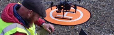
A remotely piloted aerial Green LiDAR for mapping bathymetry of shallow waters and elevation of boundary land
The project is a collaboration between the Scottish Association for Marine Science, Plymouth Marine Laboratory, British Geological Survey, National Oceanography Centre, and the UK Centre for Centre for Ecology & Hydrology, using state-of-the-art aerial equipment to provide underwater mapping (bathymetry) data where other sensors struggle or simply fail to provide solutions.
SAMS leads on one a ‘specific case of interest’ for the Green LiDAR initiative and focusses on a unique sea loch test location (Loch Craignish) with (seasonally) workable water turbidity, water surface conditions, and ground control availability. The proposed site is a target site for active seagrass restoration and is already well understood through other traditional and/or complementary methods. The site offers an excellent opportunity for benchmarking and testing of the Green LiDAR initiative.
The SAMs team have, via traditional methods, been monitoring and mapping both seagrass (e.g. Zostera marina) and Kelp bed (e.g. Laminaria hyperborea) at this site for an extended period of time. The team already has a range of strong ground control data and have commenced complementary visible and multispectral experimentation with UAV, aerial imagery and satellite classification of these habitats. The Loch Craignish site has also benefitted from an ongoing native oyster (Ostrea edulis) restoration programme seeking to restore inshore biodiversity.
The role of SAMS
The SAMS team provide UAV, remote sensing, image processing, and seagrass ecology expertise on the project; with a specific case of interest in a sea loch setting.