
UK – Overturning in the Subpolar North Atlantic Programme
The transport of heat and freshwater by the North Atlantic Subpolar Gyre greatly affects the climate of the North Atlantic and Europe through its impact on air temperature, precipitation and wind strength. It is highly significant to the region's marine ecosystems, the formation of hurricanes, and rainfall in places like the Sahel, the Amazon and parts of USA. However the Subpolar Gyre is presently inadequately measured, and no ocean general circulation or climate model represents it accurately. UK-OSNAP will deliver enhanced understanding of processes critical to the improvement of physics in climate models through sustained observation of ocean circulation and fluxes together with modelling and analysis.
UK-OSNAP is a partnership between SAMS, the National Oceanographic Center (NOC), and the Universities of Oxford and Liverpool. The UK-OSNAP team is developing a new observing system and innovative modelling techniques to characterise the circulation and fluxes of the North Atlantic Subpolar Gyre. We will provide a continuous record for four years (2014–18) of full-depth, trans-basin mass, heat, and freshwater fluxes in the Subpolar Gyre. Our second aim is to quantify and understand the response of circulation, and heat and freshwater fluxes to local (e.g. Greenland ice sheet melting) and remote forcing (e.g. Agulhas leakage), within the conceptual framework of the Atlantic Meridional Overturning Circulation.
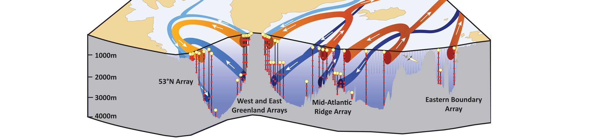
UK-OSNAP is part of an international collaboration to establish a transoceanic observing system in the subpolar North Atlantic (the OSNAP array). International OSNAP is led by USA and includes 10 further partner groups in Canada, France, Germany, the Netherlands and China. The OSNAP array is designed to complement the RAPID array and NACLIM observations, thereby providing measurements to evaluate inter-gyre connectivity within the North Atlantic.